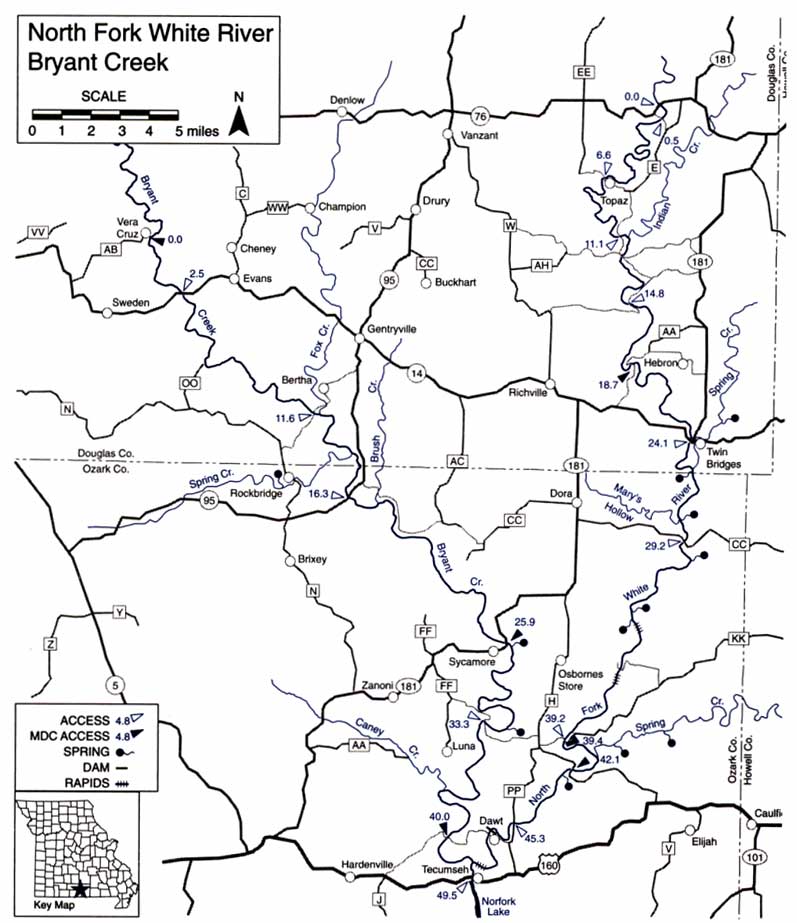
Bryant Creek
Bryant Creek is a relatively wild stream. It provides only slightly less paddling mileage than the North Fork River and is highly fishable. Less spring fed, Bryant Creek has a lower volume than the North Fork River but still has some fast riffles. The valley is lined with steep cliffs, tall sycamore trees and ever-changing sand/gravel bars. Great swimming holes!
Difficulty Class Rapids:A, I and II.
Gradients: general- 5.8; Hwy. 14 to Bertha Ford – 7.8; to Hodgson Mill- 5.3; to Tecumseh – 5.0.
Counties: Douglas, Ozark.
Bryant Creek – Mile-By-Mile Description
0.0 Vera Cruz Access on Hwy. AB. Moderately difficult access for canoes/kayaks.
2.5 Hwy. 14. Access.
4.0 Rippee Conservation Area on left.
6.3 Monastery Bridge, off Hwy. OO. May need to portage or walk boats. Check.
11.6 Bertha Ford low-water bridge access, on County Road N-345 off N and County Road 95-345 off Hwy. 95. May need to portage or walk boats. Check.
11.9 Fox Creek on left has considerable drainage area and the five miles below Hwy. 14 have a gradient of 13, but the creek is seldom runable.
14.4 Spring Creek on right. Three miles up the creek, there is a small community known as Rockbridge which has a spring, fish hatchery, mill and store. Rockbridge is best reached from the Bertha Ford, off Hwy. N. L
16.3 Hwy. 95 low-water bridge and Bell School. Access.
17.5 Brush Creek on left. A fair road on the left bank parallels the creek for about 1.3 miles below here.
24.0 Private campground on right.
25.9 Hwy. 181 low-water bridge at Aid-Hodgson Mill. Sycamore Access on right below bridge. Gravel ramp. Until a few years ago, this water mill was still in operation. Its stone ground flours, which are now ground at a modern factory in Gainesville, are sent throughout the nation. The spring, which furnished water power for the mill, has an average daily flow of 24 million gallons and has been ranked as 15th in size in the state. The eight-mile section of the creek above here is excellent fly-fishing water.
29.4 North side of The Narrows. It is two miles around Muleshoe Bend from this point, but only 0.2 mile as the crow flies. The next bend in the river is wider and is known as Horseshoe Bend.
32.3 Brixey Spring on left. The spring is often obscured by willows, but its branch is easily seen where it enters the creek.
33.3 Warren Bridge low-water access. Road connects Hwys. FF and H. Excellent swimming hole below the bridge.
37.5 Caney Creek on right.
40.0 Florence C. Cook Access on right, on County Road 308, off Hwy. 160. Dirt ramp.
42.6 Junction with North Fork. Next access 0.4 mile downstream. Don’t miss the last rift, just above this access. See North Fork for description.
|
The North Fork of the White River combines a relatively constant flow of pristine water from large springs with some of the best whitewater in the Missouri Ozarks. Since its upper reaches are in the Mark Twain National Forest, it retains some wilderness character and has good watershed protection. The section from Hwy 14 to Hwy H is near-wilderness. It includes some fine stands of short-leaf pine as well as several large springs.
The river is almost always floatable from Dora (Hammond Camp access, mile 29.2) down to Norfork Reservoir . Although the gradient of the lower sections is not spectacular (generally flat water), the volume is good.
Difficulty Class Rapids: A, I and II.
Gradients: general- 7.5; Hwy. HH to Round Valley Ford – 10.4; to Twin Bridges – 8; Hammond Camp – 6.7; to Hwy. H – 6.4; to Tecumseh take-out – 5.6.
Counties: Douglas, Ozark, Howell useful for road connections.
Northfork River – Mile-By-Mile Description
0.0 Hwy. 76 Bridge. Access.
0.5 Low-water bridge on connecting road between Hwys. 76 and E. Access.
6.6 Low-water bridge and spring at Topaz. An old mill remains standing. Access.
11.1 Slab ford. Access.
11.4 Indian Creek enters on left.
12.2 Osborn Ford low-water bridge in Round Valley, on County Road AH-260 off Hwy. AH and County
Road 284 off Hwy. 181.
14.8 Hale Ford Bridge access on County Road 275 off Hwy. 181 and County Road W-278 off Hwy.
16.1 Fiddle Springs Hollow on left.
18.7 Bridge on connecting road between Hwys. AA and 14. Hebron Access on left, on County Road 279 off Hwy. 14. Gravel ramp.
24.1 Hwy. 14 Bridge at Twin Bridges. Other bridge is over Spring Creek. Access and camping. Roadside park on left bank just above Hwy. 14 Bridge is a popular access and campground. Store between bridges.
25.9 Spring Creek enters on left. The lower 8 miles of the creek have a gradient of 12.5 but it is more a wading/fishing stream than a floating stream and tends to be blocked by logs and other obstacles. Big Spring, 2.5 miles upstream, is only a third magnitude spring.
26.0 Hicks Spring on right just below the mouth of Spring Creek.
28.2 Mary’s Hollow and creek on right. Spring up hillside on opposite side of river.
29.2 Hammond Camp Access just off Hwy. CC. Concrete bridge on West Plains Road. Forest Service North Fork Recreation Area and campground on left.
29.9 Blue Spring on left, at river level. The flow is seldom less than 7 million gallons per day.
33.3 North Fork spring issues from rock ledge on left.
33.5 Upper branch of Rainbow (Double) Spring on right. Lower branch enters river 1500 feet downstream from source. No admittance. Private use only. This is rated as the fifth largest spring in the state with mid-summer flows of up to 137 million gallons per day. There is a rocky riffle on the bend just below the mouth of the lower spring.
35.0 McKee Bridge. Private use only.
36.0 The Falls is merely a rock ledge about 2-3 feet high. Chute is best handled from the left and go toward the right, but check first.
39.2 Blair Bridge, concrete low-water bridge, on extension of Hwy. KK to Hwy. H. Access. It is necessary to pull boats over this bridge. Approach with caution, since a broadside approach in medium-high water could result in being swamped and pinned against the upstream side. Just below the bridge are some old concrete bridge piers which produce a tricky channel in low water.
39.4 Blair Bridge Access on left, on County Road H-354 off Hwy. KK.
39.9 Private campground on right.
40.9 Spring Creek on left, is fed by numerous springs, none of them large. It has a gradient of 14 on the 6 miles above its mouth but access to it is poor except at the Duncan Ford 2.3 miles upstream. It has often been floated from this point in springtime and provides a good ride, but a float from Cureall (12 miles) could entail much walking. 42.1 Hwy. H low-water bridge. Patrick Bridge Access at northeast side of bridge. Gravel ramp. Althea Spring, rated as Missouri’s 23rd largest, is just downstream on the left. 42.3 Althea Spring Branch enters the river at a fast riffle.
43.6 Private campground on right.
45.3 Hwy. PP Bridge. This is a high bridge, but the old road goes down to the water for easy access.
47.0 Dam Mill Dam. Water is backed up for about a quarter mile by this low dam. The dam has been run in high water, but it is a “canoe buster” and you must know the right spot. It is easily “portaged” by sliding the canoe down a shallow chute on the right end of the dam where there is also a rough path around the dam. There is a good rapids below the dam which is easily run.
47.1 Dam Bridge. Going under this bridge in high water is dangerous. Approach with caution and make sure there is clearance! The Dawt Mill is one of the most picturesque of those still operating in the area. The run from here to Tecumseh access has a number of riffles depending on lake level.
48.8 Repeating Riffle. This is the last drop when the lake is high. A ledge produces good standing waves which
white water enthusiasts rerun by using a strong upstream eddy on the right to carry them to the ledge again with little paddling effort.
49.1 Junction with Bryant Creek.
49.5 U.S. Army Corps of Engineers Tecumseh Access and campground on right. |